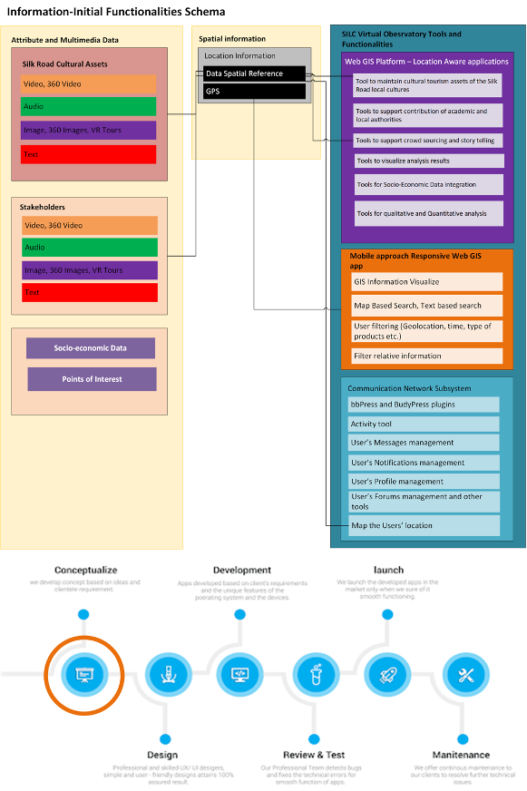
The information that the SILC Virtual Observatory will manage is constituted by attribute and multimedia data for the:
- Silk road cultural assets
- Silk road and Project Tourism stakeholders
- Socio-economic open data for the region
- Tourism Points of Interest
Furthermore, the spatial reference of the collected information will be used to integrate and include the location based information in the Web GIS System. Technologies such as the Global positioning System (GPS) are available for use by the Web GIS applications to support spatially enabled analysis and location aware Points of Interest finding.
The GIS platform, an integral tool of the web – platform Observatory, will incorporate and present the inputs to the different Groups of Activities but it will also present the results of these Groups of Activities. GIS systems will be used, as a base communication and dissemination tool, giving the ability to present thematic maps of the Silk Road Local Cultures footprint and tourism potential through web applications.
During the implementation of the project, the Observatory will be given the opportunity to partially feed data from external users-stakeholders that will be involved in the project's actions, making it more efficient and sustainable and facilitating its long-term operation. At the same time, highlighting the coherence and logic of the proposed actions, the sustainability of the Observatory will be achieved through the active involvement and cooperation of the SILCNET network, which will communicate both during the Program and after its expiration through the subsystem to be integrated on the Observatory web-platform. Based on the abovementioned description regarding the scope of the observatory and the main objectives the following schema of components was assembled:


